Chapter 3 - Communities
The three buttons below will link to pages with information and images of each type of community.
Chapter 2 discussed the creation of the county and the reasons for the creation of the many small communities and their demise. I will cover this in a little more detail here. In the 1800’s when the various villages were formed. Roads were dirt and travel was only possible by foot or by horse. The weather had a great impact on travel. During spring rains, the roads could be nothing but muddy trails where wagons could be mired down. During winter snow, travel could be impossible because of heavy drifting. This caused the small communities to become isolated and all needs had to be met locally.
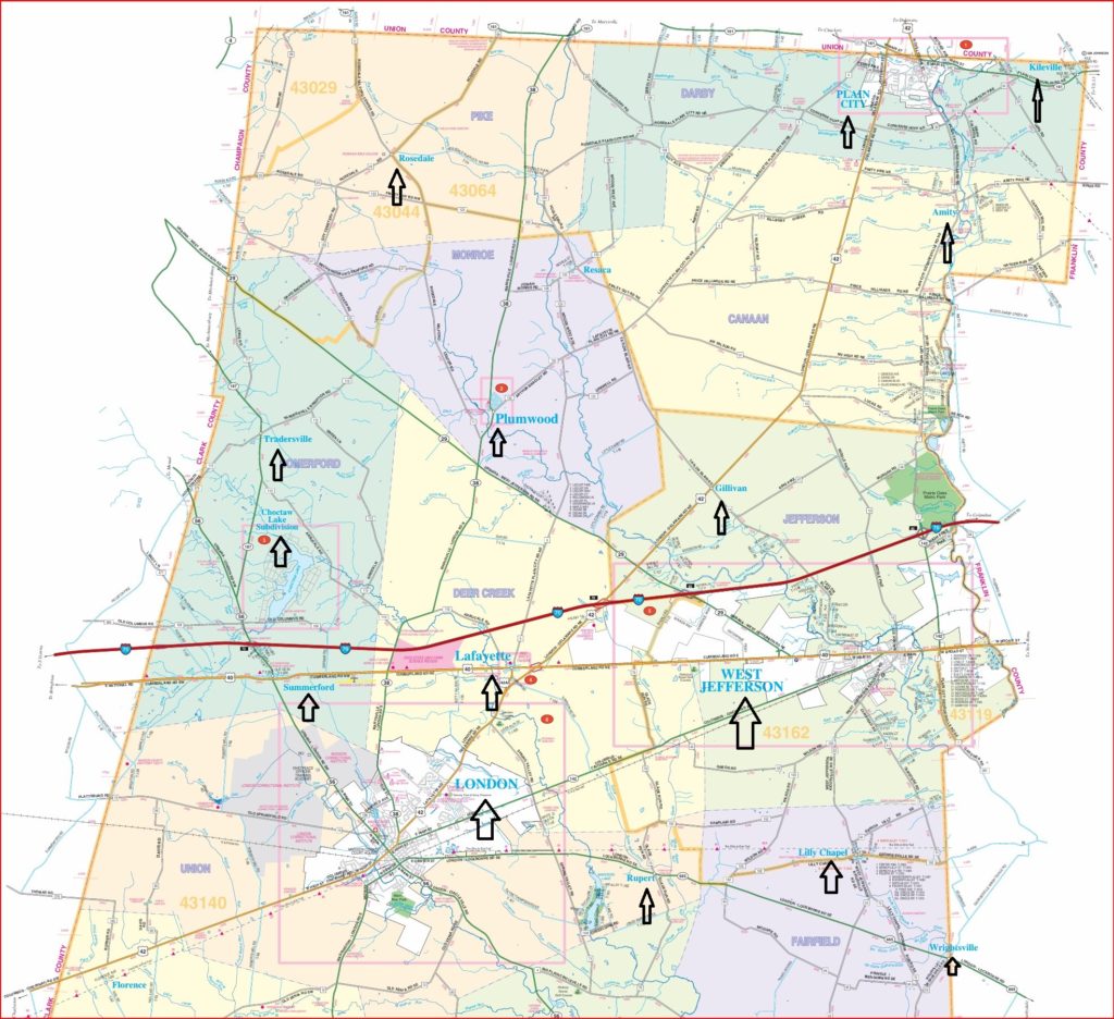
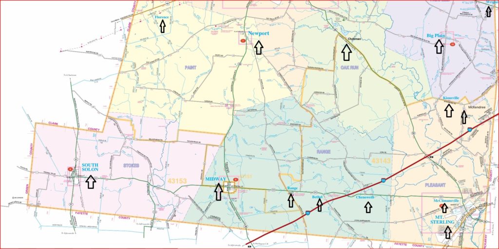
List of Communities:
Incorporated: London, Midway, Plain City, South Solon, West Jefferson
Non-Incorporated: Amity, Big Plain, Chenoweth, Chrisman, Florence, Gillivan, Kileville, Kiousville, Lilly Chapel, Madison Lake, McClimansville, McKendree, Newport, Range, Resaca, Rosedale, Rupert, Summerford, Tradersville, Wrightsville
Census Designated: Lake Choctaw, Lafayette, Plumwood
- LIST OF TOWNSHIPS IN MADISON COUNTY
- Canaan Twp (Amity)
- Darby Twp (Plain City and Kileville) Named after Wyandot Chief Darby
- Deer Creek (Lafayette)
- Fairfield Twp (Big Plain, Lilly Chapel, Kiousville and Wrightsville)
- Jefferson Twp (West Jefferson and Gillivan)
- Monroe Twp (Resaca and Plumwood)
- Oak Run Twp (Chrisman)
- Paint Twp (Newport and Florence)
- Pike Twp (Rosedale)
- Pleasant Twp (Mt Sterling, McClimansville and McKendree)
- Range Twp (Midway, Range and Chenoweth)
- Somerford Twp (Choctaw Lake, Summerford and Tradersville)
- Stokes Twp (South Solon)
- Union Twp (London, Madison Lake and Rupert)
In addition, there are some ghost towns, where nothing exists to recognize that there was community. This is a list from a website about Ohio Ghost Towns. The link opens to Madison County.
1. Carter was at the intersection of US 40 and Glade Run – All that is left is Wright Cemetery.
2. Darby Crest – Jefferson Twp, at the intersection of Riverside and Darby drives along Big Darby Creek, south of US 40.
3. Deer Creek Village – Somerford Twp, on Arbuckle Rd between SR 187 and Gwynne Rd (This was a Native American town, founded in 1794 by Tecumseh and was used as winter home), It was abandoned in 1812.
4. Deersville, Stoke Twp. Its location is unknown. It was listed in The Ohio Gazetteer between 1833-1841.
5. Johnstons – Had a Post Office 1828-1844 on Yankeetown-Chenoweth Rd at the intersection of Johnston Rd.
6. Lawrenceville (aka Limerick) was laid out in 1816 by Thomas Gwynne on his land about 1.5 miles northwest of present day Lafayette. in 1816 a tavern was opened by Angus Ross. A post office was on 2 July 1825. When the National Road (US 40) opened, it went south of Lawrenceville and the village began dying. By 1915 nothing was left but a pasture. The population is unknown.
7. Markley – Somerford Twp, was on US 40 at intersection of Markley Rd along Deer Creek. A remnant is the Diamond Rock Stock Farm barn. There was a school on the North Side of Markley Rd.
8. Myers – Union Twp. Located on Davis Rd at the railroad crossing between Old Springfield Rd and US 42. It was on the Cleveland, Cincinnati, Chicago and St Louis RR. It had a school on the south side of Old Springfield Rd. Mail was sent out from an express office on the railroad.
9. New Hampton. It was on the road from Franklinton to Springfield and was settled in 1806. When US 40 was built, the town was moved along the new National Road. After the Little Miami Railroad was built through Jefferson (now West Jefferson), it took revenue from New Hampton which was soon abandoned in 1883 with only a Baptist church remaining. New Hampton became Jefferson (now West Jefferson) It was on Frey Ave near the Hampton Cemetery. Historical marker on Frey Ave.
10. Nioga – Pleasant Twp. was on SR 56 at the intersection of Robinson Rd.
11. Roberts – Jefferson Twp. was on US 40 at the intersection of SR 29. A remnant is Pleasant Hill Cemetery. The town founded in in early 1800’s by Thomas and Susan Roberts who came from Virginia. They owned most of what is now the west side of West Jefferson and the Columbus and Xenia Railroad came through their land.
12. Wahoo – Deer Creek Twp. A Post office was there 1852-1867. No remnants exist. It was on SR 29 between SR 38 and the Northwest Twp border. It had a church and school The school was on the SW corner of the intersection of SR 29 and SR 38. There is now a roundabout where Wahoo existed. Some older residents say this location is not correct, but I can’t find records. The GNIS code for Wahoo is 1070586 but the GNIS database has no information about Wahoo.
I have found references in the old Madison County history books of a community called Blairtown. It had a sawmill and the Blair Chapel Methodist Church. It may have been somewhere near Gillivan, perhaps on a road leading to West Jefferson. The founder was a Blair who is buried in the Pleasant Hill Cemetery in West Jefferson (Also known as the Blair Cemetery). Was this the location of Blairtown and a church?
The 1875 Atlas of Madison County shows these communities. I have not been able to find them. In Canaan Township was West Canaan, located somewhere within south-west of Amity perhaps on Plain City Georgesville Rd. Fairfield township had two communities California and Warnersville. East of Midway was Dansville.
The following list are links to each of Madison Counties Communities. The five incorporated communities are first by population size in 2022, followed by the unincorporated villages in alphabetical order and then the three Census Designated Locations (CDP) Choctaw, Lafayette, Plumwood.